
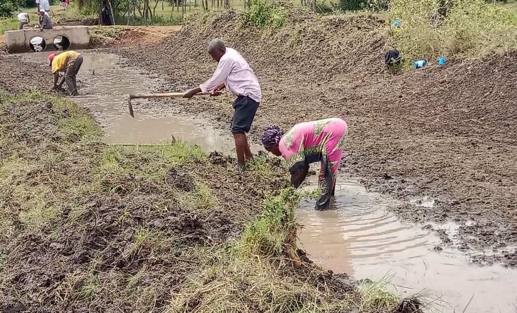
Residents of Nyando and Kadibo Sub-counties in Kisumu County are taking proactive measures in addressing persistent flooding that has plagued the community for many years by digging drainage channels.
The community-led initiative done in partnership with the Victoria Institute for Research on Environment and Development (VIRED) and the local Disaster Management Committee aims to redirect excess water during the rainy season into Lake Victoria away from their homes and farmland.
The community, which is largely composed of farmers, has long suffered recurring losses whenever it rained, as River Nyando frequently overflows its banks, submerging homesteads and agricultural land.
Kochieng’ West Location Disaster Risk Management Committee Chairperson George Otieno Obop observed that the community-driven disaster prevention and resilience approach has significantly reduced the impact of floods in the area.
“We still witness floods around the villages in small proportions for about one to two days during the rains, but when the rains stop, most of the water flows downstream into the lake,” he explains.
Obop called on the government’s intervention to facilitate the construction of flood control infrastructure such as dykes, canals and desilting of River Nyando to eradicate perennial flooding in the area.
“We are appealing to the government or any other organization to help the community construct canals, open the river banks and digging more water pans. We need many of these pans so we can continue farming even during droughts and ensure food security,” he said.
The ongoing flood control initiative supported through a grant funding from the United Nations Development Programme (UNDP), include constructing water channels, creating water-retention ponds and reviving river channels by planting bamboo trees.
Prof Philip Raburu, an Environmentalist and Aquatic Scientist from the University of Eldoret, notes that Nyando Basin experiences two extreme climatic conditions comprising of drought and floods.
“Nyando river drainage basin is like a semi-arid area and immediately it rains there is a lot of floods crippling the ability of thousands of residents to survive in the face of an escalating climate crisis,” Prof Raburu explained during an interview with Kenya News Agency.
The alternating adverse conditions, Prof Raburu noted has influenced the region to record high rate of food insecurity compared to the national figures.
He explains that the flooding in Nyando region is as a result of the runoffs coming from the highlands.
Prof Raburu asserted that Nyando, is a flood plain receiving water from the highlands catchments of Kericho, Mau forest, Tinderet forest and South Nandi forest.
“When it rains, all the rainwater flows down to the plain area. Due to the deforestation that has taken place in the upper catchment areas, the level of flooding has increased downstream,” he said.
The Scientist informed that sufficient vegetation and grass facilitate water seeping through the ground drastically reducing the water volume flowing downstream.
“This highland catchment is having a lot of agricultural activities and a lot of deforestation has taken place over the years especially along the riverbanks,” Prof. Raburu revealed.
He decried that in the sugarcane growing areas like Chemelil and Muhoroni, farmers have cultivated up to the riverbanks.
The practice, Prof. Raburu warned, leaves no buffer zone that allows water seeping to reduce the amount of water flowing downstream.
“If we have enough vegetation, forest cover and grasses in the upper catchment, rain draining downwards will have to take a long time, most of it seeping underground before it comes to the main river channel. But because of deforestation, water that comes from the highlands takes a shorter time to reach the floodplains,” he explained.
The water, he added, will be coming like a torrent and by the time it reaches the lowlands like Ahero or Ombaka, the water will be too much, causing the rivers to burst leading to flooding.
Prof Raburu acknowledged that the launch of the flood mitigation campaign had brought hope, unity, and practical change to the local communities.
The campaign, he said, was designed and coordinated by VIRED, to help address recurrent flooding, food insecurity and climate challenges in Nyando, targeting over 500 households.
Prof Raburu, also the founding Director of the VIRED, a Non-Governmental Organization (NGO) emphasized that effort to reduce flood risk and increase well-being requires a collective effort from various stakeholders.
“We are supporting the non-structural ways of controlling floods and the minimal structural issues where the community members can use their hands to do things like digging the water channels, building the water retention pans and planting bamboo seedlings along the river banks,” he said.
The organization provides working tools such as hoes, spades, shovels, rakes, and wheelbarrows for the residents and volunteers to tackle the drainage systems and open waterways to restore the free flow of rain water.
Through the collaborative spirit, at least 100 kilometers of water channels has been opened up in Kobura Ward, Nyando Constituency, transecting from Kobura location through to Bwanda Location in Kabonyo/Kanyagwal Ward.
In Nyamware South Sub Location, Kochieng’ West Location, an additional 100 kilometers of water channels have been constructed, transforming areas that were previously cut off by floodwaters into viable agricultural land.
“Locals are already benefitting because we dug the channels just before the rain starts and the farms, which they had abandoned because of flooding; right now they have ploughed them,” Prof. Raburu confirmed.
According to the scientist, the initiative is not just about clearing waterways, but it focuses on empowering residents to take ownership of their environment.
“In every activity, we do not do it for them. They do it themselves. For instance when we are making water channels or the water retention ponds, it is easy to bring a tractor to clear the place within a few minutes but instead we prefer community involvement, which is key in building ownership and responsibility for the project,” he explained.
Prof. Raburu revealed that none of the project participants receive cash payments. Instead, VIRED compensates their efforts through a ‘food for work’ program.
The locals enter a mutual agreement with the organization to dig about 10 – 15 meters of the channel per day to earn a voucher as a gesture of appreciation.
“This voucher can be redeemed in the shops within the local community so the resources are circulating within the same community,” he said.
The water pans created at various spots across the region were aimed to act as natural water reservoirs to collect and store rainwater.
“The collected water can be used in growing vegetables and domestic use during the dry season,” he said.
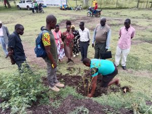
To stabilize the riverbanks and reduce flood risks, the locals have planted more than 1,000 bamboo seedlings across 5 kilometers along Miriu and Ombeyi Rivers in Kadibo Sub-County.
“Bamboo trees have a very good root network that will compact the soil so that the soil will be able to control erosion, so even if the water is full during the floods like what is going on right now, it will stabilize the banks,” Prof. Raburu said.
Beyond the physical interventions, VIRED and its partners have also placed a strong emphasis on education and awareness.
Prof. Raburu said that women and youth in the area have been trained on climate smart agriculture in a bid to improve livelihoods.
“We have been working very closely with the government officers, including the agriculture extension officers, water engineers, agroforestry officers, and some other organizations like Kenya Red Cross to train the communities on how to carry out climate smart agriculture,” he noted.
“This area is predominantly a rice-growing area, through Climate Smart Agriculture, we want to introduce them to planting traditional vegetables and fruits like onions, tomatoes. We want them to grow both cash crops and food crops to also increase their nutrition,” he explained.
Prof. Raburu also observed that all residents undergo capacity-building sessions to foster project understanding and sustainability.
The Executive Director of the Resilience Action Network Africa (RANA), Aggrey Aluso, emphasized that communities should not be seen merely as victims of disasters but as frontline actors in building resilience.
“Local preparedness initiatives, community-led risk mapping, and access to information are key for faster response during emergencies. Resilience must be built around communities’ fundamental rights to health, safe water and sanitation, adequate housing, and a healthy environment,” Aluso stated.
The partnership between VIRED, government institutions and the residents of Nyando and Kadibo Sub-counties stands as a model for community-driven disaster prevention and resilience.
By Robert Ojwang’


